
After listening to me harping on about walking in the Lakes, my friend Beth decided she would like to go hill walking. As it would be her first walk, we wanted something with not too many miles, but at the same time, managing to satisfy Beth’s motto of “go big or go home”. The Langdale Pikes with their stunning scenery and little bits of scrambling opportunity were hopefully, going to be the perfect walk. So, joined by Angela, we set off early one Saturday morning in July.

We arrived at the National Trust car park at Sticklebarn (postcode LA22 9JU) by about 9.30 and after the usual messing around, including forgetting my camera, finding I had it then forgetting to lock my car, we were on our way. The sun was shining brightly as we set off up the path alongside Stickle Ghyll at the back of the pub. It was a baking hot day – another in a long line of dry days.
There is no easing in on this walk. Very quickly, the path began to climb and as we reached a wooden bridge, the craggy mountain scenery came into view. We crossed the bridge (there were no trolls this time), climbed a stile, then followed a brief tree lined path in dappled shade before the steep path went vertical. OK, I may be exaggerating, but the ascent ahead certainly made itself known in no uncertain terms.


It was fab being out, but hard work in the sun. We weren’t in a hurry though, and this truly was a place to savour. When it came apparent that a sit down, refuel and rehydrate was just what was needed, we stopped at the side of the path admiring the view over to Lingmoor Fell as other, more hardened hikers continued on upwards. But we know, it’s a marathon, not a sprint (also my motto for all you can eat) and we sat, took in the views, and watched the sheep and people enjoying their day on the fells.

Feeling refreshed, we set off on our way, taking it all in. One of the great things about going easy is all the things you spot on the way up – like this massive rock with amazing texture. I wonder how long has it been there and how many people may have leaned on it to catch their breath?

Stickle Ghyll was remarkably dry. The many days of hot weather meant it certainly wasn’t the gushing torrent I had seen in the past. I had excitedly packed my new water filter so I could give it a try, but I was also happy to be carrying three litres of water, despite the extra weight, as everywhere was pretty dry. Ahead, the pitched path was becoming more rough, yet there were still delicate flowers seemingly growing straight out of the rock.


As we got higher, the heat was sapping the energy from our legs but route was getting more exciting, spurring us onwards. The skyline was getting closer, promising a new view beyond and there was some nice scrambling over big rocks, letting us feel like we were really exploring. Here and there were tufts of heather, brightening the grey of the rocks.


After some more rock hopping, we crested the skyline and were met with the magnificent cliff of Pavey Ark. The cool water of Stickle Tarn looked inviting – a perfect place to cool down tired feet before having another bite to eat. Jack’s Rake, the hair raising scramble diagonally across the rock face to the summit of Pavey Ark could be clearly seen, but this would be a route for another day.


We had, instead, chosen to take the North Rake, as named by Alfred Wainwright – a less exposed route to the summit of Pavey Ark. We followed a path to the right hand side of the lake alongside Bright Beck; the stream cutting a deep fissure in the ground at one point, with trees overhanging precariously. As the path levelled out, Sergeant Man came into view in the distance.


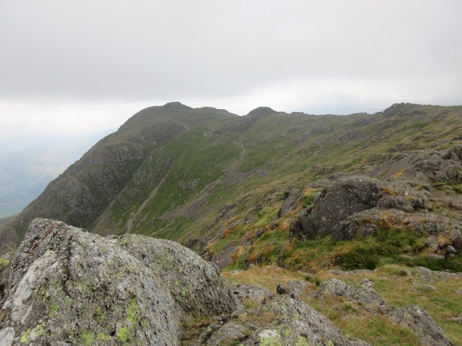
After passing the line of the cliff of Pavey Ark, we turned left, jumping over Bright Beck to begin our second feels like vertical climb of the day. The good thing about a steep climb is, at least for my part, the requirement to stop for a breather, which gives you time to look around at the surrounding fells and hummocky glacial landscape. We have a lot to thank glaciers for. As we reached the point where Easy Gully met our route, we could peer down and get a fabulous view of Stickle Tarn, Lingmoor Fell and the Coniston fells beyond.


The rocky path continued onwards, passing a sprinkling of harebells as we gradually gained height, from time to time needing the use of hands to clamber through the rocks


Eventually, the path levelled off and we reached the rocky slabs of the summit of Pavey Ark, our first Wainwright of the day and Beth’s first mountain! Gazing out from the top of the fell, Stickle Tarn looked a long way down. We could also see a little tarn that we had no idea was just above us when we had eaten our dinner. It was much cooler now so we had a brew and something more to eat. Ah, a mountain brew.


From here, we could also see the bulk of Harrison Stickle, the next fell for the day.
Ready to go, we left the rocks of Pavey Ark and tramped over the grass, coming to a couple of little tarns (we were slightly in the wrong place, but I did realise quite quickly) and passing a quartz striped baby mountain. We turned left to correct our route and head towards Harrison Stickle.


The path snaked its way over the top of the amphitheatre that housed Stickle Tarn giving an alternative view of the cliff rising out of the lake.


It wasn’t long till we had climbed to summit of Harrison Stickle, the highest of the Langdale Pikes, with Windermere nestled in the background. The gloom that we had encountered on Pavey Ark had cleared, giving way to blue skies and more sunshine.


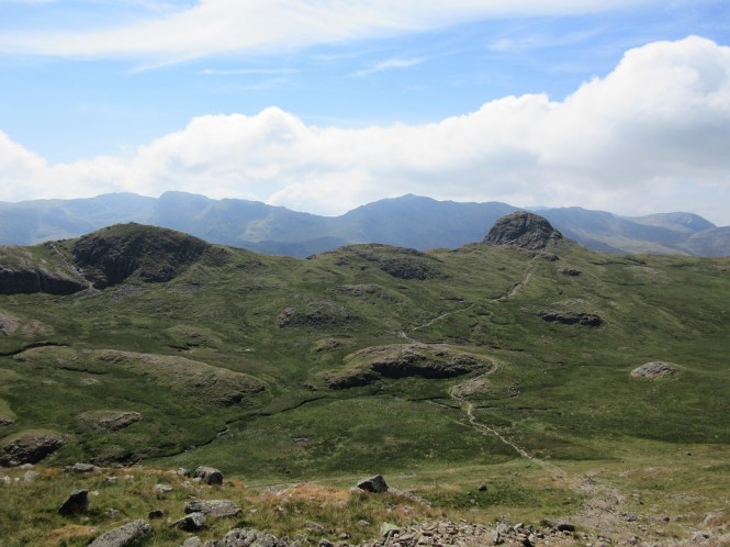
Looking westwards, we could the perfect dome of our next summit – Pike o’ Stickle. To the left of it was Loft Crag, and behind, Bow Fell and Crinkle Crags.
But before we could tramp the half mile across the grass to the very appealing scramble to the top Pike o’ Stickle, we had to negotiate the steep rocky descent from the summit of Harrison Stickle. Our path finding here was cautious. At one point short legs forced a retreat back up to find an easier route, as the step down was just too far, even with the use of my bum. I wouldn’t have been surprised to learn that a short walk round would reveal an easier path that didn’t require the use of the backside, but we had a fun scramble down the rocks, stopping to admire the views to Pike of Blisco on the other side of the valley. Long summer days might mean lots of claggy factor 50 (for my sensitive skin anyway), but it also means lots of extra hours of sunlight giving longer to linger and really just take everything in.


Soon enough, we found our way onto flatter ground. It was a leisurely stroll, crossing a stream on the way to Pike o’ Stickle, whose proper mountain top (much like my Ill Bell) I was already beginning to fall in love with. Behind us were the steep crags of Harrison Stickle, and sure enough, a seemlingly easier path off the summit further round. Never mind – the rocks were more fun.


From a distance, it was hard to see how we were going to get to the top of Pike o’ Stickle, but as we drew nearer, a path winding up and round the craggy fell top became visible. As we ascended, a new view, this time towards Scafell Pike and its neighbours appeared. The last 30 to 40 metres required hands on scrambling but what an amazing top – grassy and airy with far reaching views of the Lake District in all directions. (The cover photo of this post was taken from this top). It was the type of place I could sit, quite happily, all day.


Not only is Pike o’ Stickle a gorgeous place to just be, but it is also the location of an axe factory. At the base of the dome, where the scree slopes cascade into Great Langdale, Neolithic man would work in exposed and dangerous conditions to produce fine axes from the green rock. Examples of these axes have been found as far afield as Northern Ireland and it is thought they may have been traded at Castlerigg Stone Circle near Keswick. (Thanks to Angela for the photo of me and Beth on the summit to the right)
Eventually, we made our way back down the way we had came, then followed the ridge to the last Wainwright of the day – Loft Crag. It was an easy walk, and glancing back, you could see just how steep the sides of Pike o’ Stickle are. Imagine making axes on those slopes. It was only about a third of a mile before we arrived at Loft Crag with its troll face rocks waiting for us. Across the valley a lone cloud hovered above Blea Tarn


From here, it was a about a mile and a half back to the car (and the pub) along a path that was sometimes pitched and steep and in other parts, a very welcome, grassy and level. At the top of the valley we could see Stool End Farm nestled at the foot of the Band and Oxendale and Mickleden Becks flowing from their sources high on the fells to converge into Great Langdale Back on the valley floor.


It had been a really hot day and two Herdwick sheep welcomed us back from their shady spot by the wall – look at their friendly little faces! We caught a last glimpse of Pavey Ark flanked by two rugged pyramids before we reached the pub, and a well-deserved cold pint of coke. What a walk! It was really was the perfect first hill walk. The Langdale Pikes are definitely among my favourite fells so far, especially Pike o’ Stickle. If you like the look of this walk, you can find the route we took here.


![]()

An absolutely brilliant day!! Couldn’t have asked for a better first outing… tiring but definitely worth it x
LikeLiked by 1 person